


SISTERON . LE BOIS DE LA BUCHE . ROCHER DU TURC . CRETE DU MOLLARD . BATISTON PAUL ARENE . O L

RobinMicheline
User GUIDE
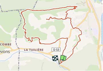

Length
16.3 km

Max alt
875 m

Uphill gradient
563 m
Km-Effort
24 km

Min alt
471 m

Downhill gradient
566 m
Boucle
Yes
Creation date :
2024-01-13 07:57:15.536
Updated on :
2024-01-13 16:33:15.397
4h34
Difficulty : Difficult

FREE GPS app for hiking
 SityTrail
IGN / Geographical institutes
SityTrail Plus
The world is yours!
About
Trail Walking of 16.3 km to be discovered at Provence-Alpes-Côte d'Azur, Alpes-de-Haute-Provence, Sisteron. This trail is proposed by RobinMicheline.
Photos


Positioning
Country:
France
Region :
Provence-Alpes-Côte d'Azur
Department/Province :
Alpes-de-Haute-Provence
Municipality :
Sisteron
Location:
Unknown
Start:(Dec)
Start:(UTM)
733867 ; 4894612 (31T) N.
Comments