


Sentier de Carlus

chripaci
User
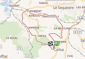

Length
9.3 km

Max alt
274 m

Uphill gradient
212 m
Km-Effort
12.1 km

Min alt
168 m

Downhill gradient
212 m
Boucle
Yes
Creation date :
2024-01-14 08:05:24.0
Updated on :
2024-01-14 10:04:30.809
1h58
Difficulty : Unknown

FREE GPS app for hiking
 SityTrail
IGN / Geographical institutes
SityTrail Plus
The world is yours!
About
Trail Nordic walking of 9.3 km to be discovered at Occitania, Tarn, Carlus. This trail is proposed by chripaci.
Positioning
Country:
France
Region :
Occitania
Department/Province :
Tarn
Municipality :
Carlus
Location:
Unknown
Start:(Dec)
Start:(UTM)
428181 ; 4859750 (31T) N.
Comments