


20240114 ste Catherine rcf

marieamelie
User
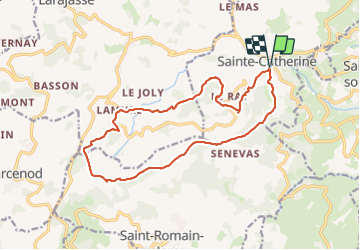

Length
16.5 km

Max alt
893 m

Uphill gradient
456 m
Km-Effort
23 km

Min alt
692 m

Downhill gradient
455 m
Boucle
Yes
Creation date :
2024-01-14 07:41:10.142
Updated on :
2024-01-14 13:47:00.993
6h01
Difficulty : Medium

FREE GPS app for hiking
 SityTrail
IGN / Geographical institutes
SityTrail Plus
The world is yours!
About
Trail Walking of 16.5 km to be discovered at Auvergne-Rhône-Alpes, Rhône, Sainte-Catherine. This trail is proposed by marieamelie.
Positioning
Country:
France
Region :
Auvergne-Rhône-Alpes
Department/Province :
Rhône
Municipality :
Sainte-Catherine
Location:
Unknown
Start:(Dec)
Start:(UTM)
622532 ; 5050476 (31T) N.
Comments