


Mont Vinaigre mont aigre

Christine460600
User
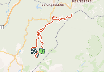

Length
19.8 km

Max alt
600 m

Uphill gradient
860 m
Km-Effort
31 km

Min alt
104 m

Downhill gradient
860 m
Boucle
Yes
Creation date :
2024-01-14 07:59:59.689
Updated on :
2024-01-14 14:43:03.201
5h49
Difficulty : Difficult

FREE GPS app for hiking
 SityTrail
IGN / Geographical institutes
SityTrail Plus
The world is yours!
About
Trail Walking of 19.8 km to be discovered at Provence-Alpes-Côte d'Azur, Var, Fréjus. This trail is proposed by Christine460600.
Positioning
Country:
France
Region :
Provence-Alpes-Côte d'Azur
Department/Province :
Var
Municipality :
Fréjus
Location:
Unknown
Start:(Dec)
Start:(UTM)
321443 ; 4815207 (32T) N.
Comments