


saint-marcel

mcterret
User
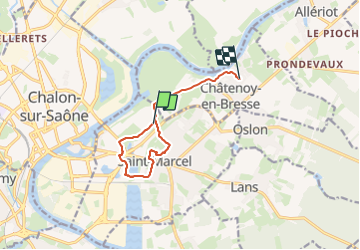

Length
8.5 km

Max alt
193 m

Uphill gradient
62 m
Km-Effort
9.3 km

Min alt
169 m

Downhill gradient
42 m
Boucle
No
Creation date :
2024-01-14 13:10:46.254
Updated on :
2024-01-14 15:51:14.613
2h34
Difficulty : Very easy

FREE GPS app for hiking
 SityTrail
IGN / Geographical institutes
SityTrail Plus
The world is yours!
About
Trail Walking of 8.5 km to be discovered at Bourgogne-Franche-Comté, Saône-et-Loire, Saint-Marcel. This trail is proposed by mcterret.
Positioning
Country:
France
Region :
Bourgogne-Franche-Comté
Department/Province :
Saône-et-Loire
Municipality :
Saint-Marcel
Location:
Unknown
Start:(Dec)
Start:(UTM)
644066 ; 5182981 (31T) N.
Comments