


Aragon plateau

Mascart
User
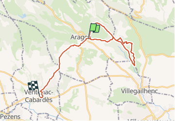

Length
15 km

Max alt
258 m

Uphill gradient
264 m
Km-Effort
18.7 km

Min alt
123 m

Downhill gradient
320 m
Boucle
No
Creation date :
2024-01-14 13:15:38.727
Updated on :
2024-01-14 16:49:38.67
2h45
Difficulty : Medium

FREE GPS app for hiking
 SityTrail
IGN / Geographical institutes
SityTrail Plus
The world is yours!
About
Trail Walking of 15 km to be discovered at Occitania, Aude, Aragon. This trail is proposed by Mascart.
Description
boucle Montipèze
Positioning
Country:
France
Region :
Occitania
Department/Province :
Aude
Municipality :
Aragon
Location:
Unknown
Start:(Dec)
Start:(UTM)
444767 ; 4793819 (31T) N.
Comments