


revieren

odindach
User
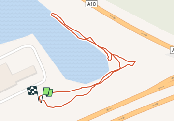

Length
656 m

Max alt
7 m

Uphill gradient
2 m
Km-Effort
682 m

Min alt
3 m

Downhill gradient
2 m
Boucle
Yes
Creation date :
2024-01-15 12:57:31.988
Updated on :
2024-01-15 13:16:36.147
18m
Difficulty : Easy

FREE GPS app for hiking
 SityTrail
IGN / Geographical institutes
SityTrail Plus
The world is yours!
About
Trail Walking of 656 m to be discovered at Flanders, West Flanders, Jabbeke. This trail is proposed by odindach.
Positioning
Country:
Belgium
Region :
Flanders
Department/Province :
West Flanders
Municipality :
Jabbeke
Location:
Jabbeke
Start:(Dec)
Start:(UTM)
504670 ; 5671231 (31U) N.
Comments