


Clécy Thury Harcourt Etape 6

RoMo
User
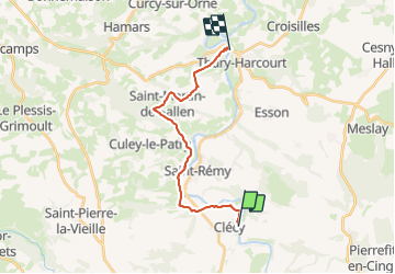

Length
15.3 km

Max alt
218 m

Uphill gradient
340 m
Km-Effort
19.9 km

Min alt
23 m

Downhill gradient
361 m
Boucle
No
Creation date :
2024-01-17 13:38:07.908
Updated on :
2024-01-17 13:40:00.512
4h31
Difficulty : Easy

FREE GPS app for hiking
 SityTrail
IGN / Geographical institutes
SityTrail Plus
The world is yours!
About
Trail On foot of 15.3 km to be discovered at Normandy, Calvados, Clécy. This trail is proposed by RoMo.
Description
Beau parcours final
Positioning
Country:
France
Region :
Normandy
Department/Province :
Calvados
Municipality :
Clécy
Location:
Unknown
Start:(Dec)
Start:(UTM)
684859 ; 5421279 (30U) N.
Comments
beau circuit varié