


18-fev-17

Jack29
User
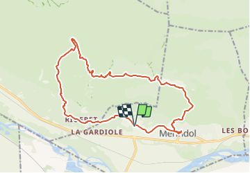

Length
19.6 km

Max alt
373 m

Uphill gradient
560 m
Km-Effort
27 km

Min alt
121 m

Downhill gradient
562 m
Boucle
Yes
Creation date :
2024-01-17 16:25:21.609
Updated on :
2024-01-17 16:51:52.375
6h09
Difficulty : Medium

FREE GPS app for hiking
 SityTrail
IGN / Geographical institutes
SityTrail Plus
The world is yours!
About
Trail Walking of 19.6 km to be discovered at Provence-Alpes-Côte d'Azur, Vaucluse, Mérindol. This trail is proposed by Jack29.
Positioning
Country:
France
Region :
Provence-Alpes-Côte d'Azur
Department/Province :
Vaucluse
Municipality :
Mérindol
Location:
Unknown
Start:(Dec)
Start:(UTM)
675597 ; 4847326 (31T) N.
Comments