


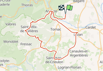
Saint-Jean de Crieulon, Saint-Félix-de-Paillière

JMJ42
User

Length
44 km

Max alt
335 m

Uphill gradient
591 m
Km-Effort
52 km

Min alt
98 m

Downhill gradient
591 m
Boucle
Yes
Creation date :
2024-01-18 10:38:49.671
Updated on :
2024-01-18 10:40:07.894
3h35
Difficulty : Medium

FREE GPS app for hiking
 SityTrail
IGN / Geographical institutes
SityTrail Plus
The world is yours!
About
Trail Mountain bike of 44 km to be discovered at Occitania, Gard, Boisset-et-Gaujac. This trail is proposed by JMJ42.
Positioning
Country:
France
Region :
Occitania
Department/Province :
Gard
Municipality :
Boisset-et-Gaujac
Location:
Unknown
Start:(Dec)
Start:(UTM)
581766 ; 4877800 (31T) N.
Comments