


SityTrail - Merindol:sur la trace des Vaudois 2

ARPF
User
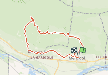

Length
20 km

Max alt
373 m

Uphill gradient
564 m
Km-Effort
28 km

Min alt
120 m

Downhill gradient
564 m
Boucle
Yes
Creation date :
2024-01-19 10:39:07.055
Updated on :
2024-01-19 10:40:39.551
6h16
Difficulty : Difficult

FREE GPS app for hiking
 SityTrail
IGN / Geographical institutes
SityTrail Plus
The world is yours!
About
Trail Walking of 20 km to be discovered at Provence-Alpes-Côte d'Azur, Vaucluse, Mérindol. This trail is proposed by ARPF.
Positioning
Country:
France
Region :
Provence-Alpes-Côte d'Azur
Department/Province :
Vaucluse
Municipality :
Mérindol
Location:
Unknown
Start:(Dec)
Start:(UTM)
677468 ; 4847195 (31T) N.
Comments