


Eguilles - le Mazet - Jas de Coussou

mhetpierre
User
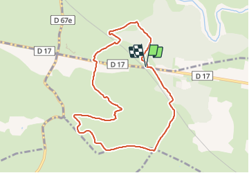

Length
9.7 km

Max alt
276 m

Uphill gradient
126 m
Km-Effort
11.4 km

Min alt
193 m

Downhill gradient
126 m
Boucle
Yes
Creation date :
2024-01-19 09:36:33.0
Updated on :
2024-01-20 10:21:40.324
2h35
Difficulty : Medium

FREE GPS app for hiking
 SityTrail
IGN / Geographical institutes
SityTrail Plus
The world is yours!
About
Trail Walking of 9.7 km to be discovered at Provence-Alpes-Côte d'Azur, Bouches-du-Rhône, Saint-Cannat. This trail is proposed by mhetpierre.
Positioning
Country:
France
Region :
Provence-Alpes-Côte d'Azur
Department/Province :
Bouches-du-Rhône
Municipality :
Saint-Cannat
Location:
Unknown
Start:(Dec)
Start:(UTM)
683755 ; 4828828 (31T) N.
Comments