


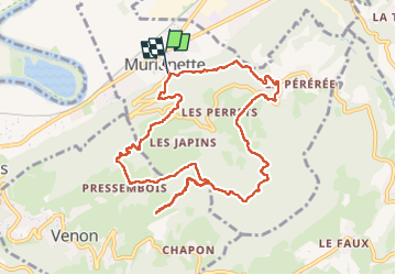
Murianette Venon en boucle

MICDURAND
User

Length
10.9 km

Max alt
713 m

Uphill gradient
518 m
Km-Effort
17.7 km

Min alt
233 m

Downhill gradient
503 m
Boucle
Yes
Creation date :
2024-01-19 08:08:12.707
Updated on :
2024-02-11 14:31:30.055
3h28
Difficulty : Easy

FREE GPS app for hiking
 SityTrail
IGN / Geographical institutes
SityTrail Plus
The world is yours!
About
Trail Walking of 10.9 km to be discovered at Auvergne-Rhône-Alpes, Isère, Murianette. This trail is proposed by MICDURAND.
Positioning
Country:
France
Region :
Auvergne-Rhône-Alpes
Department/Province :
Isère
Municipality :
Murianette
Location:
Unknown
Start:(Dec)
Start:(UTM)
721389 ; 5008049 (31T) N.
Comments