


maure viel cluB LE 24 FEVRIER

clintest
User
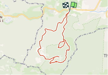

Length
9.8 km

Max alt
326 m

Uphill gradient
402 m
Km-Effort
15.2 km

Min alt
16 m

Downhill gradient
403 m
Boucle
Yes
Creation date :
2024-01-19 17:05:30.434
Updated on :
2024-01-19 17:06:22.09
3h27
Difficulty : Easy

FREE GPS app for hiking
 SityTrail
IGN / Geographical institutes
SityTrail Plus
The world is yours!
About
Trail On foot of 9.8 km to be discovered at Provence-Alpes-Côte d'Azur, Maritime Alps, Mandelieu-la-Napoule. This trail is proposed by clintest.
Positioning
Country:
France
Region :
Provence-Alpes-Côte d'Azur
Department/Province :
Maritime Alps
Municipality :
Mandelieu-la-Napoule
Location:
Unknown
Start:(Dec)
Start:(UTM)
331181 ; 4821187 (32T) N.
Comments