


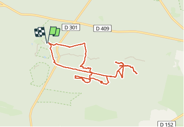
Route des carriers

Fabie Fabie
User

Length
10.4 km

Max alt
142 m

Uphill gradient
141 m
Km-Effort
12.3 km

Min alt
93 m

Downhill gradient
141 m
Boucle
Yes
Creation date :
2024-01-20 10:03:18.0
Updated on :
2024-01-20 14:29:26.777
4h25
Difficulty : Difficult

FREE GPS app for hiking
 SityTrail
IGN / Geographical institutes
SityTrail Plus
The world is yours!
About
Trail Walking of 10.4 km to be discovered at Ile-de-France, Seine-et-Marne, Fontainebleau. This trail is proposed by Fabie Fabie.
Description
Route des carriers
Positioning
Country:
France
Region :
Ile-de-France
Department/Province :
Seine-et-Marne
Municipality :
Fontainebleau
Location:
Unknown
Start:(Dec)
Start:(UTM)
472997 ; 5361826 (31U) N.
Comments