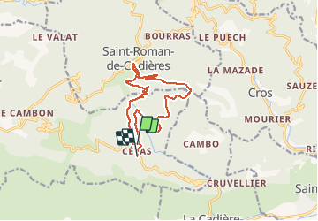
Cèzas Saint Romans de Codières

ARVIEU
User

Length
12.7 km

Max alt
877 m

Uphill gradient
432 m
Km-Effort
18.7 km

Min alt
609 m

Downhill gradient
509 m
Boucle
No
Creation date :
2015-03-04 00:00:00.0
Updated on :
2015-03-04 00:00:00.0
3h59
Difficulty : Medium

FREE GPS app for hiking
 SityTrail
IGN / Geographical institutes
SityTrail Plus
The world is yours!
About
Trail Walking of 12.7 km to be discovered at Occitania, Gard, Sumène. This trail is proposed by ARVIEU.
Description
Cézas St Roman de Codières
Positioning
Country:
France
Region :
Occitania
Department/Province :
Gard
Municipality :
Sumène
Location:
Unknown
Start:(Dec)
Start:(UTM)
562419 ; 4869812 (31T) N.
Comments