


Autour de Marck

mathis01
User
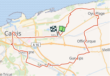

Length
47 km

Max alt
11 m

Uphill gradient
153 m
Km-Effort
49 km

Min alt
-2 m

Downhill gradient
152 m
Boucle
Yes
Creation date :
2024-01-21 10:41:35.049
Updated on :
2024-02-02 14:46:25.408
10h16
Difficulty : Very difficult
2h08
Difficulty : Very difficult

FREE GPS app for hiking
 SityTrail
IGN / Geographical institutes
SityTrail Plus
The world is yours!
About
Trail On foot of 47 km to be discovered at Hauts-de-France, Pas-de-Calais, Marck. This trail is proposed by mathis01.
Positioning
Country:
France
Region :
Hauts-de-France
Department/Province :
Pas-de-Calais
Municipality :
Marck
Location:
Unknown
Start:(Dec)
Start:(UTM)
426618 ; 5644674 (31U) N.
Comments