


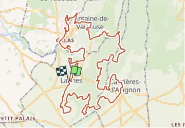
lagnes2024

mthomas30
User

Length
36 km

Max alt
393 m

Uphill gradient
997 m
Km-Effort
49 km

Min alt
70 m

Downhill gradient
997 m
Boucle
Yes
Creation date :
2024-01-21 07:31:43.191
Updated on :
2024-01-21 11:26:27.959
3h27
Difficulty : Difficult

FREE GPS app for hiking
 SityTrail
IGN / Geographical institutes
SityTrail Plus
The world is yours!
About
Trail Mountain bike of 36 km to be discovered at Provence-Alpes-Côte d'Azur, Vaucluse, Lagnes. This trail is proposed by mthomas30.
Positioning
Country:
France
Region :
Provence-Alpes-Côte d'Azur
Department/Province :
Vaucluse
Municipality :
Lagnes
Location:
Unknown
Start:(Dec)
Start:(UTM)
669743 ; 4862172 (31T) N.
Comments