


claparette

Jean-Claude BOURGUE
User
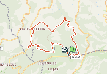

Length
11.5 km

Max alt
542 m

Uphill gradient
325 m
Km-Effort
15.8 km

Min alt
308 m

Downhill gradient
326 m
Boucle
Yes
Creation date :
2024-01-21 08:09:33.777
Updated on :
2024-01-21 12:57:50.848
4h05
Difficulty : Easy

FREE GPS app for hiking
 SityTrail
IGN / Geographical institutes
SityTrail Plus
The world is yours!
About
Trail Walking of 11.5 km to be discovered at Provence-Alpes-Côte d'Azur, Vaucluse, Buoux. This trail is proposed by Jean-Claude BOURGUE.
Positioning
Country:
France
Region :
Provence-Alpes-Côte d'Azur
Department/Province :
Vaucluse
Municipality :
Buoux
Location:
Unknown
Start:(Dec)
Start:(UTM)
691303 ; 4857221 (31T) N.
Comments