Trail Walking Écully - Le bois de Serres - Photo
 chuck
chuck

User

© OpenStreetMap contributors
Length
Length
7 km
Max alt
Max alt
311 m
Uphill gradient
Uphill gradient
146 m
Km-Effort
Km-Effort  
9 km
Min alt
Min alt
251 m
Downhill gradient
Downhill gradient
165 m
Boucle
Boucle
No
Creation date :
2024-01-21 13:01:50.303
Updated on :
2024-01-21 17:48:17.542

(0 Reviews)

Walking
Walking
2h09
Difficulty : Easy

Scan this QR Code to open this trail in the SityTrail application

FREE GPS app for hiking

Logo SityTrail SityTrail

IGN / Geographical institutes

Download SityTrail from the App Store Download SityTrail from Google Play

Logo SityTrail SityTrail World

The world is yours!

Download SityTrail from the App Store Download SityTrail from Google Play Download SityTrail on Huawei AppGallery

About

Trail Walking of 7 km to be discovered at Auvergne-Rhône-Alpes, Métropole de Lyon, Écully. This trail is proposed by chuck.

Description

Topo guide le Grand Lyon à pied

Elevation profile

Photos

Positioning

Country:
France
Region :
Auvergne-Rhône-Alpes
Department/Province :
Métropole de Lyon
Municipality :
Écully
Location:
Unknown
Start:(UTM)
637157 ; 5072058 (31T) N.

Trails nearby

Trail Walking Lyon - De Place des Archives à Monplaisir - Photo
Walking
Marie-Hélène Luton 2

Walking

Difficult
(1)
Lyon, Auvergne-Rhône-Alpes, Métropole de Lyon, France
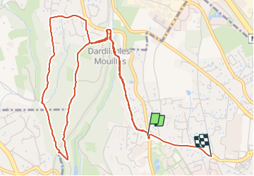
11.2 km | 12.9 km-effort
2h 55min
No
Trail Walking Marcy-l'Étoile - 69 Marcy l'Etoile et les Monts du Lyonnais - Photo
Walking
Maryma

Walking

Medium
(1)
Marcy-l'Étoile, Auvergne-Rhône-Alpes, Métropole de Lyon, France
22 km | 30 km-effort
5h 0min
Yes
Trail Mountain bike Lyon - Monts d'Or_02 - Photo
Mountain bike
philmascio

Mountain bike

Medium
(2)
Lyon, Auvergne-Rhône-Alpes, Métropole de Lyon, France
32 km | 45 km-effort
2h 54min
Yes
Trail Mountain bike Dardilly - Mont Verdun 2 - Photo
Mountain bike
simon.paume

Mountain bike

Medium
(1)
Dardilly, Auvergne-Rhône-Alpes, Métropole de Lyon, France
17.9 km | 24 km-effort
1h 38min
Yes
Trail Mountain bike La Tour-de-Salvagny - La Tourelloise 2011 30km - Photo
Mountain bike
tracegps

Mountain bike

Difficult
(1)
La Tour-de-Salvagny, Auvergne-Rhône-Alpes, Métropole de Lyon, France
30 km | 42 km-effort
2h 30min
Yes
Trail Walking Saint-Cyr-au-Mont-d'Or - s3-c_st_cyr_69450_3d_homme_paysage - Photo
Walking
vidal.galaxy

Walking

Medium
(1)
Saint-Cyr-au-Mont-d'Or, Auvergne-Rhône-Alpes, Métropole de Lyon, France
6.6 km | 9.3 km-effort
2h 6min
Yes
Trail Horseback riding Limonest - limonest2-hangar par azergues 17k - Photo
Horseback riding
ophness

Horseback riding

Medium
(3)
Limonest, Auvergne-Rhône-Alpes, Métropole de Lyon, France
18.3 km | 21 km-effort
2h 41min
No
Trail Walking Lyon - Fnac - Photo
Walking
ricoux

Walking

Easy
(1)
Lyon, Auvergne-Rhône-Alpes, Métropole de Lyon, France
1.9 km | 2.3 km-effort
18min
No
Trail Walking Lyon - cuire et ile barbe - Photo
Walking
maclobar

Walking

Very difficult
Lyon, Auvergne-Rhône-Alpes, Métropole de Lyon, France
17.8 km | 23 km-effort
5h 16min
No


Close
My subscriptions