


Marignac laspeyre fait 2024

pidjam
User
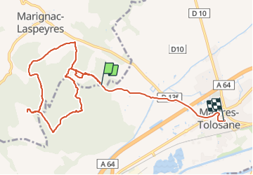

Length
10.6 km

Max alt
505 m

Uphill gradient
268 m
Km-Effort
14.4 km

Min alt
266 m

Downhill gradient
327 m
Boucle
No
Creation date :
2024-01-21 12:53:45.877
Updated on :
2024-01-21 15:27:26.507
1h53
Difficulty : Medium

FREE GPS app for hiking
 SityTrail
IGN / Geographical institutes
SityTrail Plus
The world is yours!
About
Trail Walking of 10.6 km to be discovered at Occitania, Haute-Garonne, Marignac-Laspeyres. This trail is proposed by pidjam.
Positioning
Country:
France
Region :
Occitania
Department/Province :
Haute-Garonne
Municipality :
Marignac-Laspeyres
Location:
Unknown
Start:(Dec)
Start:(UTM)
336015 ; 4785436 (31T) N.
Comments