


21 01

micheleuvrard
User
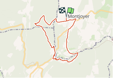

Length
9.1 km

Max alt
336 m

Uphill gradient
194 m
Km-Effort
11.7 km

Min alt
204 m

Downhill gradient
193 m
Boucle
Yes
Creation date :
2024-01-21 13:12:51.28
Updated on :
2024-01-21 15:41:50.61
2h28
Difficulty : Medium

FREE GPS app for hiking
 SityTrail
IGN / Geographical institutes
SityTrail Plus
The world is yours!
About
Trail Walking of 9.1 km to be discovered at Auvergne-Rhône-Alpes, Drôme, Montjoyer. This trail is proposed by micheleuvrard.
Positioning
Country:
France
Region :
Auvergne-Rhône-Alpes
Department/Province :
Drôme
Municipality :
Montjoyer
Location:
Unknown
Start:(Dec)
Start:(UTM)
646868 ; 4926492 (31T) N.
Comments