


sentier forestier AH

domheitz
User
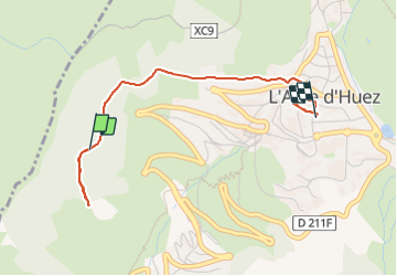

Length
3.1 km

Max alt
1839 m

Uphill gradient
60 m
Km-Effort
3.9 km

Min alt
1797 m

Downhill gradient
56 m
Boucle
No
Creation date :
2024-01-22 10:50:57.582
Updated on :
2024-01-22 12:24:08.111
50m
Difficulty : Easy

FREE GPS app for hiking
 SityTrail
IGN / Geographical institutes
SityTrail Plus
The world is yours!
About
Trail Walking of 3.1 km to be discovered at Auvergne-Rhône-Alpes, Isère, Huez. This trail is proposed by domheitz.
Positioning
Country:
France
Region :
Auvergne-Rhône-Alpes
Department/Province :
Isère
Municipality :
Huez
Location:
Unknown
Start:(Dec)
Start:(UTM)
267988 ; 4997119 (32T) N.
Comments