


St Mathieu de Tréviers - lac du Jeantou

jpc34
User
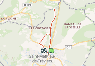

Length
5.9 km

Max alt
155 m

Uphill gradient
67 m
Km-Effort
6.8 km

Min alt
98 m

Downhill gradient
67 m
Boucle
Yes
Creation date :
2024-01-22 13:24:01.286
Updated on :
2024-01-22 15:28:15.843
2h03
Difficulty : Very easy

FREE GPS app for hiking
 SityTrail
IGN / Geographical institutes
SityTrail Plus
The world is yours!
About
Trail Walking of 5.9 km to be discovered at Occitania, Hérault, Saint-Mathieu-de-Tréviers. This trail is proposed by jpc34.
Positioning
Country:
France
Region :
Occitania
Department/Province :
Hérault
Municipality :
Saint-Mathieu-de-Tréviers
Location:
Unknown
Start:(Dec)
Start:(UTM)
569876 ; 4846730 (31T) N.
Comments