


SURCENEUX LONGEMER

surceneux
User
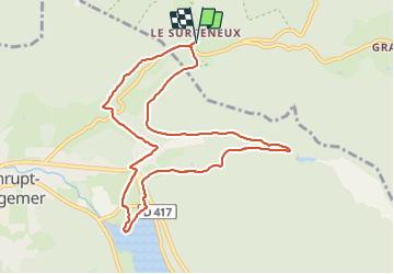

Length
9.5 km

Max alt
846 m

Uphill gradient
210 m
Km-Effort
12.3 km

Min alt
733 m

Downhill gradient
210 m
Boucle
Yes
Creation date :
2024-01-22 13:39:41.802
Updated on :
2024-01-22 16:49:29.623
1h45
Difficulty : Easy

FREE GPS app for hiking
 SityTrail
IGN / Geographical institutes
SityTrail Plus
The world is yours!
About
Trail Walking of 9.5 km to be discovered at Grand Est, Vosges, Ban-sur-Meurthe-Clefcy. This trail is proposed by surceneux.
Description
SURCENEUX MAISON FORESTIÈRE BELBRIETTE LONGEMER CHAPELLE ST FLORENT RETOUR CROIX BLEUE ? D23 LES FIES SURCENEUX
Positioning
Country:
France
Region :
Grand Est
Department/Province :
Vosges
Municipality :
Ban-sur-Meurthe-Clefcy
Location:
Unknown
Start:(Dec)
Start:(UTM)
347836 ; 5329047 (32U) N.
Comments