


Mont St Père du 23-01-2024

VANDERPUTTENMi
User GUIDE
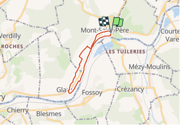

Length
8.9 km

Max alt
95 m

Uphill gradient
86 m
Km-Effort
10 km

Min alt
56 m

Downhill gradient
85 m
Boucle
Yes
Creation date :
2024-01-23 12:46:52.376
Updated on :
2024-01-23 20:43:42.461
2h16
Difficulty : Medium

FREE GPS app for hiking
 SityTrail
IGN / Geographical institutes
SityTrail Plus
The world is yours!
About
Trail Walking of 8.9 km to be discovered at Hauts-de-France, Aisne, Mont-Saint-Père. This trail is proposed by VANDERPUTTENMi.
Photos

Positioning
Country:
France
Region :
Hauts-de-France
Department/Province :
Aisne
Municipality :
Mont-Saint-Père
Location:
Unknown
Start:(Dec)
Start:(UTM)
536135 ; 5435845 (31U) N.
Comments