Trail Walking LAHITTE-TOUPIERE - Maubourguet - Lourdes - Photo
© OpenStreetMap contributors
Length
Length
61 km
Max alt
Max alt
551 m
Uphill gradient
Uphill gradient
1117 m
Km-Effort
Km-Effort  
75 km
Min alt
Min alt
200 m
Downhill gradient
Downhill gradient
970 m
Boucle
Boucle
No
Creation date :
2015-03-05 00:00:00.0
Updated on :
2015-03-05 00:00:00.0

(0 Reviews)

Walking
Walking
16h01
Difficulty : Medium

Scan this QR Code to open this trail in the SityTrail application

FREE GPS app for hiking

Logo SityTrail SityTrail

IGN / Geographical institutes

Download SityTrail from the App Store Download SityTrail from Google Play

Logo SityTrail SityTrail World

The world is yours!

Download SityTrail from the App Store Download SityTrail from Google Play Download SityTrail on Huawei AppGallery

About

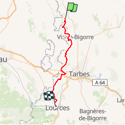
Trail Walking of 61 km to be discovered at . This trail is proposed by Marc83143.

Description

Pou quitter le GR 653 et rejoindre Oloron Ste Marie par Lourdes

Elevation profile

Positioning

Country:
France
Region :
MIDI-PYRENEES
Department/Province :
HAUTES-PYRENEES
Municipality :
LAHITTE-TOUPIERE
Location:
Unknown
Start:(UTM)
742660 ; 4816409 (30T) N.

Trails nearby

Trail Walking Moncaup - MONCAUP-Circuit vert des fontaines - Photo
Walking
Polo-31

Walking

Very easy
Moncaup, New Aquitaine, Pyrénées-Atlantiques, France
9.9 km | 13 km-effort
2h 47min
Yes
Trail On foot Moncaup - 2020-08-15_19h39m22_Cirkwi-Le_sentier_des_fontaines (1) - Photo
On foot
GUIDE
marmotte65

On foot

Easy
Moncaup, New Aquitaine, Pyrénées-Atlantiques, France
13.4 km | 17.6 km-effort
Unknown
Yes
Trail Walking Moncaup - MONCAUP  chemin des fontaines M1-fait - Photo
Walking
GUIDE
marmotte65

Walking

Easy
Moncaup, New Aquitaine, Pyrénées-Atlantiques, France
9.7 km | 12.3 km-effort
2h 41min
Yes
Trail On foot Nouilhan - Maubourguet - Marmajou - Photo
On foot
marcel.F

On foot

Easy
Nouilhan, Occitania, Hautespyrenees, France
11.9 km | 12.8 km-effort
2h 27min
Yes
Trail Walking Nouilhan - Maubourguet - Bois du Marmajou - Photo
Walking
marcel.F

Walking

Difficult
Nouilhan, Occitania, Hautespyrenees, France
11 km | 11.7 km-effort
2h 16min
Yes
Trail Walking Maubourguet - Maubourguet  Rando Pique-Nique Estirac - Photo
Walking
marcel.F

Walking

Medium
Maubourguet, Occitania, Hautespyrenees, France
16.5 km | 17.5 km-effort
3h 40min
Yes
Trail Walking Larreule - Larreule Parrabère - bois de Larreule et de Labatut - Photo
Walking
marcel.F

Walking

Medium
Larreule, Occitania, Hautespyrenees, France
16.2 km | 19.7 km-effort
4h 10min
Yes
Trail Walking Larreule - Larreule - Bois communal depuis Parabère - Photo
Walking
marcel.F

Walking

Medium
Larreule, Occitania, Hautespyrenees, France
9.1 km | 11.1 km-effort
2h 31min
Yes
Trail Walking Maubourguet - MAUBOURGUET - SUR LES SENTIERS DE L'HISTOIRE - Photo
Walking
marcel.F

Walking

Medium
Maubourguet, Occitania, Hautespyrenees, France
6.2 km | 6.7 km-effort
1h 30min
Yes


Close
My subscriptions