


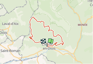
chatillon en diois col des caux serre des granges

Joel26400
User

Length
15.7 km

Max alt
1187 m

Uphill gradient
893 m
Km-Effort
28 km

Min alt
581 m

Downhill gradient
894 m
Boucle
Yes
Creation date :
2024-01-24 15:34:44.794
Updated on :
2024-01-24 15:38:25.519
6h16
Difficulty : Very difficult

FREE GPS app for hiking
 SityTrail
IGN / Geographical institutes
SityTrail Plus
The world is yours!
About
Trail Walking of 15.7 km to be discovered at Auvergne-Rhône-Alpes, Drôme, Châtillon-en-Diois. This trail is proposed by Joel26400.
Description
rando d'hiver autour de Chatillon
Positioning
Country:
France
Region :
Auvergne-Rhône-Alpes
Department/Province :
Drôme
Municipality :
Châtillon-en-Diois
Location:
Châtillon-en-Diois
Start:(Dec)
Start:(UTM)
696670 ; 4952035 (31T) N.
Comments