


Blanzat Sayat La Blade

Papou63patrick
User
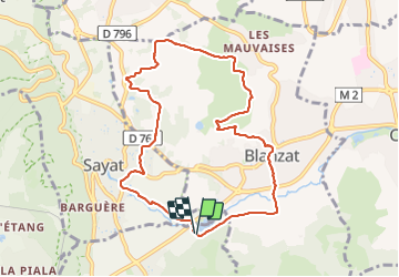

Length
9.2 km

Max alt
511 m

Uphill gradient
166 m
Km-Effort
11.4 km

Min alt
374 m

Downhill gradient
166 m
Boucle
Yes
Creation date :
2024-01-24 13:08:59.293
Updated on :
2024-01-24 16:16:26.972
3h06
Difficulty : Medium

FREE GPS app for hiking
 SityTrail
IGN / Geographical institutes
SityTrail Plus
The world is yours!
About
Trail Walking of 9.2 km to be discovered at Auvergne-Rhône-Alpes, Puy-de-Dôme, Nohanent. This trail is proposed by Papou63patrick.
Positioning
Country:
France
Region :
Auvergne-Rhône-Alpes
Department/Province :
Puy-de-Dôme
Municipality :
Nohanent
Location:
Unknown
Start:(Dec)
Start:(UTM)
505079 ; 5074039 (31T) N.
Comments