


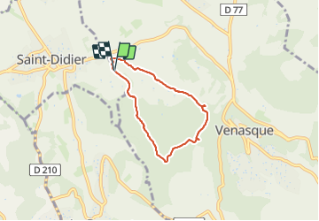
St Didier venasque

aupi
User

Length
5.5 km

Max alt
283 m

Uphill gradient
118 m
Km-Effort
7.1 km

Min alt
184 m

Downhill gradient
121 m
Boucle
Yes
Creation date :
2024-01-12 12:22:25.059
Updated on :
2024-01-25 09:13:37.104
2h03
Difficulty : Easy

FREE GPS app for hiking
 SityTrail
IGN / Geographical institutes
SityTrail Plus
The world is yours!
About
Trail Walking of 5.5 km to be discovered at Provence-Alpes-Côte d'Azur, Vaucluse, Venasque. This trail is proposed by aupi.
Positioning
Country:
France
Region :
Provence-Alpes-Côte d'Azur
Department/Province :
Vaucluse
Municipality :
Venasque
Location:
Unknown
Start:(Dec)
Start:(UTM)
670066 ; 4874561 (31T) N.
Comments