


velleron 84 arrayes

aupi
User
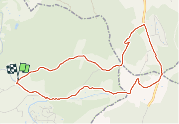

Length
6 km

Max alt
187 m

Uphill gradient
150 m
Km-Effort
8 km

Min alt
89 m

Downhill gradient
144 m
Boucle
Yes
Creation date :
2024-01-23 13:03:28.172
Updated on :
2024-01-25 09:13:39.85
2h12
Difficulty : Easy

FREE GPS app for hiking
 SityTrail
IGN / Geographical institutes
SityTrail Plus
The world is yours!
About
Trail Walking of 6 km to be discovered at Provence-Alpes-Côte d'Azur, Vaucluse, Velleron. This trail is proposed by aupi.
Positioning
Country:
France
Region :
Provence-Alpes-Côte d'Azur
Department/Province :
Vaucluse
Municipality :
Velleron
Location:
Unknown
Start:(Dec)
Start:(UTM)
664510 ; 4869797 (31T) N.
Comments