


Le Jal - Laboule

Clo0413
User
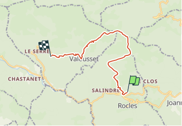

Length
11.1 km

Max alt
1201 m

Uphill gradient
919 m
Km-Effort
23 km

Min alt
457 m

Downhill gradient
773 m
Boucle
No
Creation date :
2024-01-25 12:57:55.699
Updated on :
2024-01-25 14:20:43.306
5h11
Difficulty : Medium

FREE GPS app for hiking
 SityTrail
IGN / Geographical institutes
SityTrail Plus
The world is yours!
About
Trail Walking of 11.1 km to be discovered at Auvergne-Rhône-Alpes, Ardèche, Rocles. This trail is proposed by Clo0413.
Positioning
Country:
France
Region :
Auvergne-Rhône-Alpes
Department/Province :
Ardèche
Municipality :
Rocles
Location:
Unknown
Start:(Dec)
Start:(UTM)
596612 ; 4935924 (31T) N.
Comments