


La Colette

oliviergau
User

Length
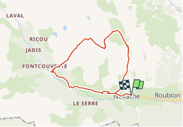
16.8 km

Max alt
2721 m

Uphill gradient
1147 m
Km-Effort
32 km

Min alt
1595 m

Downhill gradient
1148 m
Boucle
Yes
Creation date :
2024-01-27 07:51:50.828
Updated on :
2024-01-27 15:12:45.368
6h42
Difficulty : Very easy

FREE GPS app for hiking
 SityTrail
IGN / Geographical institutes
SityTrail Plus
The world is yours!
About
Trail Touring skiing of 16.8 km to be discovered at Provence-Alpes-Côte d'Azur, Hautes-Alpes, Névache. This trail is proposed by oliviergau.
Positioning
Country:
France
Region :
Provence-Alpes-Côte d'Azur
Department/Province :
Hautes-Alpes
Municipality :
Névache
Location:
Unknown
Start:(Dec)
Start:(UTM)
311471 ; 4987863 (32T) N.
Comments