


Bondoufloise 2015-03-08 56km

Lucquiaud
User
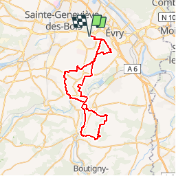

Length
56 km

Max alt
151 m

Uphill gradient
529 m
Km-Effort
63 km

Min alt
46 m

Downhill gradient
528 m
Boucle
Yes
Creation date :
2018-09-15 15:06:22.365
Updated on :
2018-09-15 15:06:22.387
5h00
Difficulty : Difficult

FREE GPS app for hiking
 SityTrail
IGN / Geographical institutes
SityTrail Plus
The world is yours!
About
Trail Mountain bike of 56 km to be discovered at Ile-de-France, Essonne, Bondoufle. This trail is proposed by Lucquiaud.
Positioning
Country:
France
Region :
Ile-de-France
Department/Province :
Essonne
Municipality :
Bondoufle
Location:
Unknown
Start:(Dec)
Start:(UTM)
454167 ; 5385217 (31U) N.
Comments