


vierves.B.2024.01.27

trusgnachjf
User
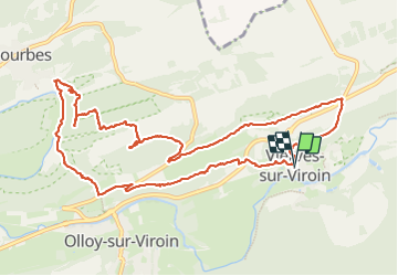

Length
11.9 km

Max alt
245 m

Uphill gradient
305 m
Km-Effort
16 km

Min alt
146 m

Downhill gradient
306 m
Boucle
Yes
Creation date :
2024-01-27 12:23:28.186
Updated on :
2024-01-27 16:07:49.594
3h42
Difficulty : Difficult

FREE GPS app for hiking
 SityTrail
IGN / Geographical institutes
SityTrail Plus
The world is yours!
About
Trail Walking of 11.9 km to be discovered at Wallonia, Namur, Viroinval. This trail is proposed by trusgnachjf.
Positioning
Country:
Belgium
Region :
Wallonia
Department/Province :
Namur
Municipality :
Viroinval
Location:
Unknown
Start:(Dec)
Start:(UTM)
616925 ; 5548801 (31U) N.
Comments