


donon

apa
User
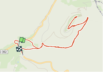

Length
6.7 km

Max alt
996 m

Uphill gradient
273 m
Km-Effort
10.4 km

Min alt
705 m

Downhill gradient
288 m
Boucle
No
Creation date :
2024-01-27 14:17:30.168
Updated on :
2024-01-27 17:31:25.256
2h27
Difficulty : Medium

FREE GPS app for hiking
 SityTrail
IGN / Geographical institutes
SityTrail Plus
The world is yours!
About
Trail Walking of 6.7 km to be discovered at Grand Est, Bas-Rhin, Grandfontaine. This trail is proposed by apa.
Description
donon
Photos

Positioning
Country:
France
Region :
Grand Est
Department/Province :
Bas-Rhin
Municipality :
Grandfontaine
Location:
Unknown
Start:(Dec)
Start:(UTM)
363147 ; 5374288 (32U) N.
Comments