


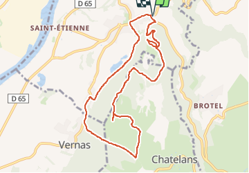
De Hières-sur-Amby à Larina

trietsch
User

Length
9.8 km

Max alt
420 m

Uphill gradient
318 m
Km-Effort
14.1 km

Min alt
214 m

Downhill gradient
318 m
Boucle
Yes
Creation date :
2024-01-27 18:33:49.41
Updated on :
2024-05-20 19:25:42.967
3h11
Difficulty : Difficult

FREE GPS app for hiking
 SityTrail
IGN / Geographical institutes
SityTrail Plus
The world is yours!
About
Trail Walking of 9.8 km to be discovered at Auvergne-Rhône-Alpes, Isère, Hières-sur-Amby. This trail is proposed by trietsch.
Points of interest


Positioning
Country:
France
Region :
Auvergne-Rhône-Alpes
Department/Province :
Isère
Municipality :
Hières-sur-Amby
Location:
Unknown
Start:(Dec)
Start:(UTM)
678803 ; 5074265 (31T) N.
Comments