


cabane des Bladas 01.2024

chrisgps
User
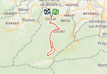

Length
12.3 km

Max alt
1348 m

Uphill gradient
799 m
Km-Effort
23 km

Min alt
565 m

Downhill gradient
798 m
Boucle
Yes
Creation date :
2024-01-25 07:57:54.446
Updated on :
2024-01-29 13:46:56.23
5h13
Difficulty : Medium

FREE GPS app for hiking
 SityTrail
IGN / Geographical institutes
SityTrail Plus
The world is yours!
About
Trail Walking of 12.3 km to be discovered at Occitania, Ariège, Ganac. This trail is proposed by chrisgps.
Positioning
Country:
France
Region :
Occitania
Department/Province :
Ariège
Municipality :
Ganac
Location:
Unknown
Start:(Dec)
Start:(UTM)
382790 ; 4755945 (31T) N.
Comments