


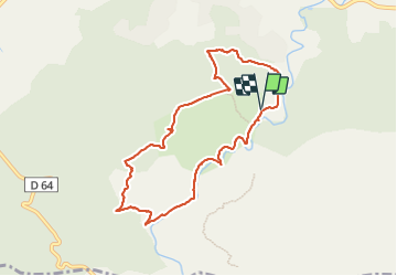
Chapelle saint probace - gorges caramy

mapomme
User

Length
8.9 km

Max alt
513 m

Uphill gradient
322 m
Km-Effort
13.2 km

Min alt
275 m

Downhill gradient
322 m
Boucle
Yes
Creation date :
2024-01-28 09:57:42.0
Updated on :
2024-01-28 13:51:07.86
3h39
Difficulty : Very easy

FREE GPS app for hiking
 SityTrail
IGN / Geographical institutes
SityTrail Plus
The world is yours!
About
Trail Walking of 8.9 km to be discovered at Provence-Alpes-Côte d'Azur, Var, Tourves. This trail is proposed by mapomme.
Description
Joli petite boucle. Église sympathique - fin au bord de l'eau plaisante (hors saison !)
Positioning
Country:
France
Region :
Provence-Alpes-Côte d'Azur
Department/Province :
Var
Municipality :
Tourves
Location:
Unknown
Start:(Dec)
Start:(UTM)
737455 ; 4808387 (31T) N.
Comments