


abbaye de St Roman

aeroseb84
User
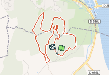

Length
6.4 km

Max alt
137 m

Uphill gradient
175 m
Km-Effort
8.8 km

Min alt
40 m

Downhill gradient
170 m
Boucle
Yes
Creation date :
2024-01-28 12:45:19.434
Updated on :
2024-01-28 14:24:42.168
1h39
Difficulty : Easy

FREE GPS app for hiking
 SityTrail
IGN / Geographical institutes
SityTrail Plus
The world is yours!
About
Trail Walking of 6.4 km to be discovered at Occitania, Gard, Beaucaire. This trail is proposed by aeroseb84.
Positioning
Country:
France
Region :
Occitania
Department/Province :
Gard
Municipality :
Beaucaire
Location:
Unknown
Start:(Dec)
Start:(UTM)
629452 ; 4854548 (31T) N.
Comments