


san martial

Beguet
User

Length
10.1 km

Max alt
448 m

Uphill gradient
399 m
Km-Effort
15.4 km

Min alt
177 m

Downhill gradient
396 m
Boucle
No
Creation date :
2024-01-28 11:14:03.755
Updated on :
2024-01-28 15:39:43.926
3h14
Difficulty : Easy

FREE GPS app for hiking
 SityTrail
IGN / Geographical institutes
SityTrail Plus
The world is yours!
About
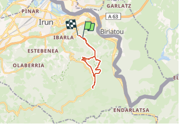
Trail Walking of 10.1 km to be discovered at Autonomous Community of the Basque Country, Gipuzkoa, Irun. This trail is proposed by Beguet.
Positioning
Country:
Spain
Region :
Autonomous Community of the Basque Country
Department/Province :
Gipuzkoa
Municipality :
Irun
Location:
Unknown
Start:(Dec)
Start:(UTM)
600273 ; 4798267 (30T) N.
Comments