


Albas Christophe

Ada11
User GUIDE
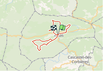

Length
17.5 km

Max alt
391 m

Uphill gradient
594 m
Km-Effort
25 km

Min alt
221 m

Downhill gradient
592 m
Boucle
Yes
Creation date :
2024-01-28 08:18:17.854
Updated on :
2024-01-28 15:43:40.358
6h45
Difficulty : Medium

FREE GPS app for hiking
 SityTrail
IGN / Geographical institutes
SityTrail Plus
The world is yours!
About
Trail Walking of 17.5 km to be discovered at Occitania, Aude, Albas. This trail is proposed by Ada11.
Description
2 boucles
1 rampaillou un peu dur et un peu long sur la fin.
De belles terres rouges.
Positioning
Country:
France
Region :
Occitania
Department/Province :
Aude
Municipality :
Albas
Location:
Unknown
Start:(Dec)
Start:(UTM)
478389 ; 4761600 (31T) N.
Comments