619,1 - Palayson - Les Flacs - Portail du Rouet - IBP 44 Bleu

ChicanneMaryse
User
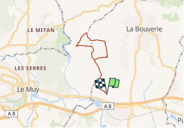

Length
10.2 km

Max alt
93 m

Uphill gradient
130 m
Km-Effort
12 km

Min alt
35 m

Downhill gradient
131 m
Boucle
Yes
Creation date :
2024-01-28 18:13:04.077
Updated on :
2024-10-30 10:39:22.58
0m
Difficulty : Medium

FREE GPS app for hiking
 SityTrail
IGN / Geographical institutes
SityTrail Plus
The world is yours!
About
Trail Nordic walking of 10.2 km to be discovered at Provence-Alpes-Côte d'Azur, Var, Roquebrune-sur-Argens. This trail is proposed by ChicanneMaryse.
Positioning
Country:
France
Region :
Provence-Alpes-Côte d'Azur
Department/Province :
Var
Municipality :
Roquebrune-sur-Argens
Location:
Unknown
Start:(Dec)
Start:(UTM)
307446 ; 4815625 (32T) N.
Comments