


bandol port d'abonnement par la frégate départ b

ego
User
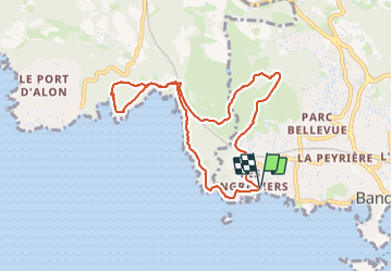

Length
9.1 km

Max alt
153 m

Uphill gradient
233 m
Km-Effort
12.2 km

Min alt
7 m

Downhill gradient
235 m
Boucle
Yes
Creation date :
2024-01-24 09:27:16.743
Updated on :
2024-01-29 12:59:29.821
2h42
Difficulty : Difficult

FREE GPS app for hiking
 SityTrail
IGN / Geographical institutes
SityTrail Plus
The world is yours!
About
Trail Walking of 9.1 km to be discovered at Provence-Alpes-Côte d'Azur, Var, Bandol. This trail is proposed by ego .
Photos

Positioning
Country:
France
Region :
Provence-Alpes-Côte d'Azur
Department/Province :
Var
Municipality :
Bandol
Location:
Unknown
Start:(Dec)
Start:(UTM)
722298 ; 4779624 (31T) N.
Comments