


la ciotat nd la garde au sémaphore

ego
User
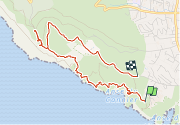

Length
5.5 km

Max alt
308 m

Uphill gradient
282 m
Km-Effort
9.2 km

Min alt
0 m

Downhill gradient
254 m
Boucle
No
Creation date :
2024-01-29 09:23:02.887
Updated on :
2024-01-29 12:59:30.906
2h19
Difficulty : Medium

FREE GPS app for hiking
 SityTrail
IGN / Geographical institutes
SityTrail Plus
The world is yours!
About
Trail Walking of 5.5 km to be discovered at Provence-Alpes-Côte d'Azur, Bouches-du-Rhône, La Ciotat. This trail is proposed by ego .
Positioning
Country:
France
Region :
Provence-Alpes-Côte d'Azur
Department/Province :
Bouches-du-Rhône
Municipality :
La Ciotat
Location:
Unknown
Start:(Dec)
Start:(UTM)
710721 ; 4782680 (31T) N.
Comments