


RR-Le Combeau Noir

raymondfn
User
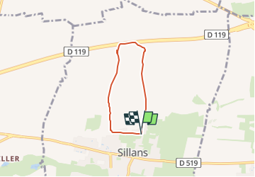

Length
4.6 km

Max alt
423 m

Uphill gradient
31 m
Km-Effort
4.9 km

Min alt
401 m

Downhill gradient
24 m
Boucle
Yes
Creation date :
2024-01-30 20:47:00.058
Updated on :
2024-02-05 10:01:56.368
1h07
Difficulty : Easy

FREE GPS app for hiking
 SityTrail
IGN / Geographical institutes
SityTrail Plus
The world is yours!
About
Trail Walking of 4.6 km to be discovered at Auvergne-Rhône-Alpes, Isère, Sillans. This trail is proposed by raymondfn.
Positioning
Country:
France
Region :
Auvergne-Rhône-Alpes
Department/Province :
Isère
Municipality :
Sillans
Location:
Unknown
Start:(Dec)
Start:(UTM)
687507 ; 5024196 (31T) N.
Comments
