


St Aubin des Chateaux et Ruffigné

chasle
User
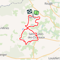

Length
28 km

Max alt
94 m

Uphill gradient
298 m
Km-Effort
32 km

Min alt
31 m

Downhill gradient
291 m
Boucle
No
Creation date :
2015-03-07 00:00:00.0
Updated on :
2015-03-07 00:00:00.0
7h03
Difficulty : Easy

FREE GPS app for hiking
 SityTrail
IGN / Geographical institutes
SityTrail Plus
The world is yours!
About
Trail Walking of 28 km to be discovered at Pays de la Loire, Loire-Atlantique, Ruffigné. This trail is proposed by chasle.
Description
Balisage jaune
Etangs et calvaires
Chênes et chataigniers
Positioning
Country:
France
Region :
Pays de la Loire
Department/Province :
Loire-Atlantique
Municipality :
Ruffigné
Location:
Unknown
Start:(Dec)
Start:(UTM)
612841 ; 5290161 (30T) N.
Comments