


La Lranche sur mer pointe d'arcay

taguette
User
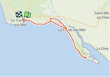

Length
32 km

Max alt
9 m

Uphill gradient
85 m
Km-Effort
33 km

Min alt
-3 m

Downhill gradient
84 m
Boucle
Yes
Creation date :
2024-02-01 10:15:39.938
Updated on :
2024-02-01 16:33:34.69
6h16
Difficulty : Difficult

FREE GPS app for hiking
 SityTrail
IGN / Geographical institutes
SityTrail Plus
The world is yours!
About
Trail Walking of 32 km to be discovered at Pays de la Loire, Vendée, La Tranche-sur-Mer. This trail is proposed by taguette.
Positioning
Country:
France
Region :
Pays de la Loire
Department/Province :
Vendée
Municipality :
La Tranche-sur-Mer
Location:
Unknown
Start:(Dec)
Start:(UTM)
620719 ; 5133575 (30T) N.
Comments