


fournel mimosas 3_o4dUz

clintest
User
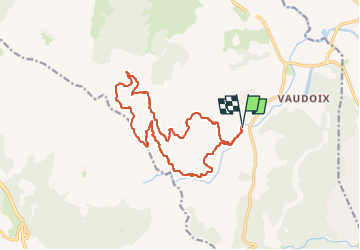

Length
16.3 km

Max alt
352 m

Uphill gradient
409 m
Km-Effort
22 km

Min alt
14 m

Downhill gradient
408 m
Boucle
Yes
Creation date :
2024-02-01 19:10:58.52
Updated on :
2024-02-01 19:10:58.52

FREE GPS app for hiking
 SityTrail
IGN / Geographical institutes
SityTrail Plus
The world is yours!
About
Trail of 16.3 km to be discovered at Provence-Alpes-Côte d'Azur, Var, Roquebrune-sur-Argens. This trail is proposed by clintest.
Positioning
Country:
France
Region :
Provence-Alpes-Côte d'Azur
Department/Province :
Var
Municipality :
Roquebrune-sur-Argens
Location:
Unknown
Start:(Dec)
Start:(UTM)
311501 ; 4807528 (32T) N.
Comments