


Caire Val- les Costes -St Marcellin

Berpav
User
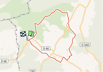

Length
8.6 km

Max alt
334 m

Uphill gradient
162 m
Km-Effort
10.7 km

Min alt
209 m

Downhill gradient
163 m
Boucle
Yes
Creation date :
2024-02-02 15:15:33.136
Updated on :
2024-02-02 15:16:20.747
2h26
Difficulty : Medium

FREE GPS app for hiking
 SityTrail
IGN / Geographical institutes
SityTrail Plus
The world is yours!
About
Trail Walking of 8.6 km to be discovered at Provence-Alpes-Côte d'Azur, Bouches-du-Rhône, Rognes. This trail is proposed by Berpav.
Positioning
Country:
France
Region :
Provence-Alpes-Côte d'Azur
Department/Province :
Bouches-du-Rhône
Municipality :
Rognes
Location:
Unknown
Start:(Dec)
Start:(UTM)
686124 ; 4839083 (31T) N.
Comments
agréable